
South Warwickshire Local Plan – Preferred Options Consultation ended 7th March
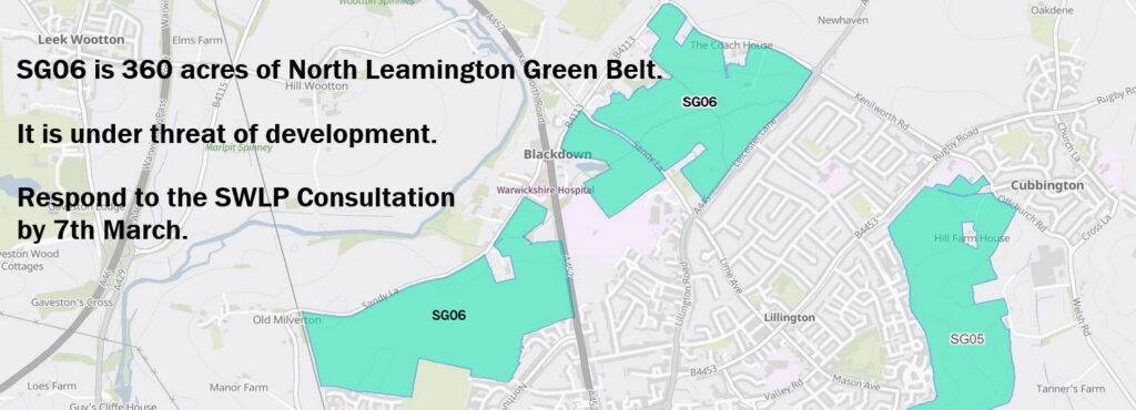
Thanks to everyone who responded to the consultation to try to save the green belt in North Leamington from development. You can still read abut the plans here.
Old Milverton and Blackdown Parish Council drew on a number of arguments in its response. Click on the tabs below or open a pdf here:
-
Argument 1
-
Argument 2
-
Argument 3
-
Argument 4
-
Argument 5
-
Argument 6
-
Argument 7
South Warwickshire’s housing need can be met without building on green belt land.
The Local Plan is pursuing a spatial growth strategy of ‘Sustainable Travel and Economy’. In pursuit of this it identifies 24 potential Strategic Growth Locations as well as 12 potential New Settlements that conform to this strategy.
The Local Plan needs to make provision for 30,000 additional new dwellings in South Warwickshire to meet government targets (Section 4.1, Table 3). These will be located in the strategic growth locations and new settlements.
The Local Plan's own Sustainability Appraisal shows that:
- Strategic Growth Locations which are NOT in the green belt have capacity for 48,500 dwellings (Table 5.1).
- New Settlements which are NOT in the green belt have capacity for a further 6,000 dwellings (Table 6.1).
This means that it is possible to meet housing need without building on green belt land. Sufficient capacity exists at Strategic Growth Locations outside the Green Belt to meet the Local Plan dwelling requirements to 2050. Therefore, exceptional circumstances cannot be met to release green belt sites to meet the housing requirements of Warwick District and Stratford on Avon District.
We are aware that South Warwickshire is bounded by Coventry and Redditch and there may be unmet needs from those areas that have to be accommodated. However, it is clear from comments on this matter in the previous Inspector’s Report (2017), that development to meet the unmet needs of Coventry will need to be located adjoining Coventry, rather than the edge of Leamington. The same principle would apply to Redditch.
In short, it is not necessary to remove green belt land in North Leamington from the West Midlands Green Belt for the purposes of the South Warwickshire Local Plan.
SG06 is not a ‘sustainable location’.
The Local Plan puts sustainability at its heart and wants new developments to be “20-minute neighbourhoods”, where local services, including train stations and bus routes, are within a 10 minute walk. SG06 is not a sustainable location. It is a 30 minute walk to Leamington train station from the closest point and a one hour walk from the furthest.
While the nearest transport hub is at least 1.5 miles and up to 2.7 miles away from points in SG06, the SWLP’s Housing and Economic Development Needs Analysis notes the short distance to the M40/A46 junctions (paragraph 4.52). This suggests an underlying acceptance of a continued reliance on cars, which in turn would exacerbate already unsustainable levels of traffic.
The original layout of the town and the subsequent development in the 19th and 20th centuries precludes the construction of major new cross-town access routes. This would be an issue if more houses were built north of Leamington because they would need to access the retail and employment sites which predominantly lie to the south of the town.
We believe that building houses in SG06 would promote car use rather than reduce it.
The Green Belt around North Leamington continues to fulfil the stated purposes of Green Belt land.
The five purposes of Green Belt land are to:
A. check the unrestricted sprawl of large built-up areas
B. prevent neighbouring towns merging into one another
C. assist in safeguarding the countryside from encroachment
D. preserve the setting and special character of historic towns
E. assist in urban regeneration, by encouraging the recycling of derelict and other urban land.
An analysis commissioned by Old Milverton & Blackdown Joint Parish Council at the last round of consultation shows how SG06 meets all five of the above criteria.
In addition to SG06, numerous other sites along the A452 were put forward in the Call for Sites. Once land is removed from the Green Belt for development this cannot be undone and a precedent is set which makes it easier for adjoining swathes of land to be built on. Therefore, were development to go ahead, the amount of green belt land ultimately lost could be far greater than just the 360 acres of SG06.
The Green Belt Review informing the Plan is flawed.
There are fundamental flaws in the Green Belt Review carried out by Arup in 2024.
1) Definition of ‘large built-up area’
The main flaw is the rationale for excluding Leamington Spa, Warwick and Stratford-upon-Avon from the definition of ‘large built-up area’ on the basis that they ‘…sit on the edge of the Green Belt, rather than within it’.
This leads the Green Belt Review to the presumption ‘…that the Green Belt was not intended to prevent their growth, and thus it does not seem appropriate to consider them as part of the “large built-up area” ’.
This ‘presumption’ does not stand any logical scrutiny. If land on the northern edges of Leamington, Warwick and Stratford-upon-Avon was not intended to prevent their outward ‘sprawl’ it would not have been designated as Green Belt. Their growth was to be accommodated to the south and constrained by Green Belt to the north. In terms of being large built-up areas, Government Planning Inspectors have found other similar sized towns in the West Midlands Green Belt to be ‘large built-up areas’, most recently at a planning appeal at the start of this year [APP/E1855/W/22/3310099]. The Planning Inspector denied planning permission, finding that a site on the edge of Kidderminster (popn 57,000) makes a major contribution to Green Belt Purpose A. (Leamington Spa’s population is 54,000).
2) Assessments of SG06
Of the four parcels of land at SG06, three are assessed as making ‘a moderate contribution’ to the purposes of the green belt, and one ‘a weak contribution’. The assessment was primarily desk-based, with just one visit to a single viewing point at each site. The viewing points were:
- the entrance to the footpath off Bamburgh Grove
- the lay-by north of North Leamington School
- the entrance to the footpath off Leicester Lane
- the entrance to private fields off Westhill Rd, described in the report as ‘a derelict site’.
The essential characteristics of Green Belts are their openness and their permanence, and at least three of these viewing points give no sense at all of the openness of each location. This continues the practice of relying on desk-based judgements without an understanding of the local area. The same thing happened in 2023, when assessments for the North Leamington Green Belt, tucked away in a 477 page appendix to the Sustainability Appraisal, made inaccurate judgements such as:
- development at these locations would be “unlikely to lead to coalescence of settlements”.
- development would give rise to “a minor negative impact on the recreational experience associated with these, and surrounding, footpaths”.
Legal precedent makes it clear that green belt land to the north of Leamington Spa makes a strong contribution to Green Belt Purpose A. There needs to be a more informed analysis of the contribution of green belt land at SG06.
Old Milverton & Blackdown Joint Parish Council is continuing to analyse the Green Belt Review and will provide further updates.
The farmland is high quality agricultural land and makes an important contribution to sustainability and security of food supply.
National policy remains clear that where significant development of agricultural land is demonstrated to be necessary, areas of poorer quality should be preferred to those of a higher quality (NPPF, 2024). The highest concentration of ALC Grade 2 land around Leamington Spa and Warwick is to the north and east of Leamington Spa. The land making up these sites is, therefore, considered to be a scarce resource of high value for sustainable food production. The Government seeks to protect against the loss of such land from non-agricultural development. This policy will continue to grow in significance as the cost of imported wheat and grain drives up domestic food production needs.
The same proposals were rejected by the Planning Inspector in 2017.
The Planning Inspector’s 2017 response to the existing Local Plan for Warwick District states that there is a need “to maintain the separate identity of surrounding villages such as Leek Wootton and Cubbington and avoid significant reductions in the gap to Kenilworth” (p. 18, para 91). It also states that: “Development of the land in question would involve a substantial expansion of the built up area into currently open countryside to the north of Leamington Spa. It would have a significant adverse impact on the openness of the Green Belt and the character and appearance of the area” (p.34, para 201).
This area has already suffered significant damage to openness and character with the construction of the HS2 railway line causing interruption of farmland and wildlife habitat. Further adverse development in the area would compound the significant adverse impacts that the Planning Inspector referred to in 2017. If anything, arguments for maintaining the Green Belt’s contribution to the openness of the countryside, food production and biodiversity are stronger now than eight years ago when these comments were made.
SG06 contributes to the SWLP principles ‘healthy, safe and inclusive’ and ‘biodiverse and environmentally resilient’.
These are two of the five ‘overarching principles’ of the Local Plan. SG06 contributes to them as follows:
i. A healthy, safe and inclusive South Warwickshire: In surveys residents say that the open Green Belt location is the thing they value most about living in this area, with benefits for both physical and mental health. Use of the public footpaths increased markedly during the Covid 19 pandemic lockdown and has continued since.
Area SG06 is distinctive green belt land because it is traversed by two miles (3.2km) of rural footpaths. Calculating this in terms of metres of footpath per hectare, we see that SG06 has a higher proportion of footpaths than the West Midlands Green Belt as a whole:
Land in the West Midlands Green Belt overall = 16m per hectare
Land in SG06 = 22m per hectare
This makes it much more than fields providing openness and views. It makes a direct contribution to the health and wellbeing of the thousands of people who use the area each year. The views of some of them are summarised here.
ii. A biodiverse and environmentally resilient South Warwickshire: A recent local study, carried out over the course of 2023-2024 has observed a diverse range of plant and wildlife in SG06. The hedgerows, field margins and managed meadows provide habitats for:
- roe deer, Reeves muntjac deer, badgers, rural foxes and otters
- birds on the RSPB ‘red list’ including skylarks, swifts, fieldfares, house sparrows and starlings
- birds of prey such as sparrowhawks, peregrine falcons, kestrels, buzzards and red kites
- butterflies, dragonflies and damselflies
- plants which are vital for conserving the wildlife chain, for example musk mallow, bush vetch and yellow archangel.
The high quality agricultural land is now farmed by a single modern, established farming business. The land continues to provide rural employment and undergo diversification of farming techniques. Its use for modern arable, grazing and wildlife refuge benefits the environment as well as helping to preserve the characteristics of a rural Victorian village in Old Milverton.
Allowing development on SG06 would undermine important principles that the Local Plan is elsewhere seeking to follow.
Here are the details of our full response:
1. Read the full text of the answers that we submitted on the consultation portal here.
2. Read our Supporting Document which outlines our full argument against development in SG06.
3. Read the Supporting Document prepared by Howard Cole, our planning consultants, which we also submitted to the SWLP team.
4. Read a Supporting Document summarising the views of local people about how important this area is to them.
Next steps
A final ‘Preferred Option’ is anticipated in December 2025 with submission to the Government for approval in September 2026. The current SWLP timetable can be viewed here. We anticipate that information about the Preferred Options Consultation (Jan-March 2025) will be published before then, as well as the second stage of the Green Belt Review.
The Parish Council is following developments closely and discussing with our advisers and we will keep you updated. Subscribe below to receive emails from us and please contact us if you have any questions.